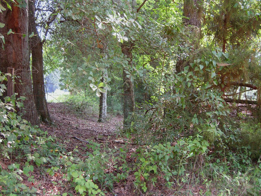
The Old Federal Road provided a route into and through Alabama for early settlers of the region. The precise ground location of the Old Federal Road remains unknown in many places and in others rests under modern roadways or developments. The known route is dotted with the discontinuous remnants of historical and archaeological landscapes, the exact locations known by a handful of local community members and informed historians. Written histories and a surviving cultural memory recorded in oral tradition recall events that took place along the roadway during the settling of Alabama. This resource would not have been possible without funding from the Federal Road Initiative, the Auburn University at Montgomery School of Liberal Arts, and a research and education grant from the Intergraph Corporation. Portions of the data presented on this site were collected by the University of South Alabama with funding from the Alabama Department of Transportation.
Welcome to the Old Federal Road website. This page represents a collaborative effort by scholars from three Alabama universities, Auburn University at Montgomery, Auburn University, and The University of South Alabama, and members of the community interested in historic preservation. It contains information collected by academics, scholars, and agencies with an interest in preserving the history of the Old Federal Road and developing tourism along the historic route. The highway had an enduring influence on Alabama's growth and development throughout the nineteenth and twentieth centuries. The interactive map page is driven by technology provided by Google Inc. If you are already familiar with Google Earth, you will find the map controls are similar. The user interface enables you to turn on and off layers by checking the box to the left of the legend entry and view or download information about selected map locations by clicking on the location symbol in the map window. Selections from published works are accessible in Adobe Acrobat format with permission of the University of Alabama Press. Clickable links to articles about the Old Federal Road on the Encyclopedia of Alabama website can be found along the historic route as well. Other icons contain the geographic coordinates and photographs of historic places and remaining traces of the Old Federal Road etched upon the modern-day cultural landscape of Alabama. Imagery includes 19th century surveys and maps produced by the Alabama Department of Transportation and local experts.
If you have an active research project that would benefit from specific geospatial data, complete and submit a research registration form. To qualify, you must be affiliated to a university which supports scholarly research or a governmental agency in need of specific locational information. After applications are verified, a user identification and password will be issued to access sensitive data housed on this site. The Auburn University at Montgomery Old Federal Road Initiative as well as contributors to this site must be cited as sources for any information downloaded from this website and redistributed, reprinted, or reproduced in any form. Use of photographs is subject to copyright. This site is designed provide visitors with the opportunity to submit additional information concerning the Old Federal Road which could be included on the interactive map. We welcome your input. Submissions will be authenticated by our staff and consultants prior to incorporation. Please feel free to contact us with any comments or suggestions you might have regarding this site. Maps, documents, and images are reproduced by permission. We hope you find your experience both enjoyable as well as informative. We will be constantly adding information to this site so stop back frequently.

Dr. Terance L. Winemiller Project Director, AUM
Dr. Virginia Ochoa Winemiller Senior Geographer, AUM
Dr. Craig Sheldon Senior Archaeologist, AUM
Mr. Mark Dauber Photographer - Consultant
Dr. Greg Waselkov Senior Archaeologist, USA
Dr. John Cottier Senior Archaeologist, AU
Dr. Kimberly Bracket Sociologist, AUM
Dr. Denise Davis-Maye Social Historian, AUM
Dr. Yanyi Djamba Demographer, AUM
Ms. Nancy Grisham Anderson Literature, AUM
Dr. Jon Marcoux Archaeologist, AUM
Dr. Kathryn Braund Historian, AU
Dr. Nelya McKenzie Communication - Publicity, AUM
Ms. Raven Christopher Archaeologist, USA
Ms. Chris Johnson Consultant, AVisual Advantage
Christopher Blair, AUM
Kate Geesey, AUM
Louise Speirs, AUM
Anne West, AUM
Auburn University at Montgomery is pleased to announce a program of study in Geographic Information Systems (GIS) and Geographic Information Science GISc for undergraduate and graduate students. In addition to the degree programs specializing in GIS and GISc, Auburn University at Montgomery offers a five-course intensive study program leading to a Certificate in Geographic Information Systems which satisfies the academic requirements for certification by the Geographic Information Systems Certification Institute (GISCI). A PowerPoint presentation describing GIS and the certificate program is available on this website. Contact twinemi1@aum.edu for additional information on opportunities in GIS at Auburn University at Montgomery.
Auburn University at Montgomery and all other contributors to this site make no warranty about the accuracy of geographic coordinates provided.
| Copyright © 2012 Auburn University Montgomery P.O. Box 2444023 | Montgomery, AL 36124-4023 | (334) 244-3000 |
| Please send email comments and suggestions to twinemi1@aum.edu |